 Youlgrave, Alport &
Middleton
Youlgrave, Alport &
Middleton
in the Derbyshire Peak
District
NB this website is under construction
|
NB this website is under construction |
|
|
Travel
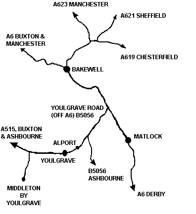
Youlgrave is off the B5056 about 2 miles off the A6 from Matlock to Bakewell. Approximate travelling times from nearby locations are :-
Buses to Bakewell run every xxx between xx and xx every day of the week. There is a bus from Sheffield ..... Chesterfield Station, on the London to Sheffield line, is about 40 minutes by car Buxton, on the Manchester to ?, line in about 35 minutes by car? Manchester is about 1 hour and a half by car East Midlands is 1 hour and a half by car Sheffield is about 1 hour 15 minutes by car Y http://www.streetmap.co.uk/streetmap.dll?grid2map?x=421250&y=364250&zoom=1&isp=213&ism=500&arrow=y?84,52 M http://www.streetmap.co.uk/streetmap.dll?grid2map?x=419750&y=363250&zoom=1&isp=213&ism=500&arrow=y?19,118 both
http://uk2.multimap.com/map/browse.cgi?X=420000&Y=365000&gride=&gridn=&width=700&height=400&client=M6&db=hcgaz&scale=50000&multimap.x=452&multimap.y=262 |
|
|